-
Got the Contributing Memberships stuff finally worked out and made up a thread as a sort of "How-To" to help people figure out how to participate. So if you need help figuring it out, here's the thread you need to take a look at -> http://www.corvetteflorida.com/forums/showthread.php?t=3581 Thank you, everyone! Rich Z.
You are using an out of date browser. It may not display this or other websites correctly.
You should upgrade or use an alternative browser.
You should upgrade or use an alternative browser.
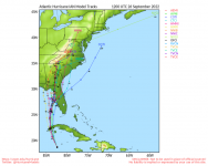
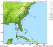
Possible hurricane (Ian) - 2022
- Thread starter Rich Z
- Start date
85vette
Active member
Fortunately the powers that be cancelled our load for Orlando and Lakeland for this week due to the uncertainty of Ian. I'm not unhappy about it. I hope and pray that where ever it lands that the damage and danger is minimal.
We passed a lot of bucket trucks headed south on 65 in north Alabama this morning heading down to stage for the power outages that we know are going to occur. I couldn't see what state they were from though.
We passed a lot of bucket trucks headed south on 65 in north Alabama this morning heading down to stage for the power outages that we know are going to occur. I couldn't see what state they were from though.
CHASZ51
Z51
Be safe. Leave if you have to.
I am going down with the ship no matter what. Gotta keep the vette from getting wet and telescopes. Will update during the storm unless power goes out.
Yeah man, stay safe. You can always replace material things.
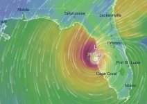
Looks like you may get a couple years worth of rain from Ian. Seems like models are showing it stalling out and just sitting there just off the coast for at least 12 hours. Tornadoes could be a real problem.
I bailed out when Michael came up this way. Another big storm heads this way, Connie and I are out of here for a few days.
CHASZ51
Z51
Yeah man, stay safe. You can always replace material things.
Looks like you may get a couple years worth of rain from Ian. Seems like models are showing it stalling out and just sitting there just off the coast for at least 12 hours. Tornadoes could be a real problem.
I bailed out when Michael came up this way. Another big storm heads this way, Connie and I are out of here for a few days.
Gonna be a long wind event. No surge for me it looks like so that is good. And maybe no weather for you at all.
85vette
Active member
https://weather.com/storms/hurrican...cane-ian-forecast-landfall-cuba-florida-tampa
Yeah, looks like Ft. Myers will get the brunt of it. I saw FDOT camera footage of I-4 and I-75 this morning. Westbound I-4 was empty! Everybody heading east and north on 75! Can't blame them.
Yeah, looks like Ft. Myers will get the brunt of it. I saw FDOT camera footage of I-4 and I-75 this morning. Westbound I-4 was empty! Everybody heading east and north on 75! Can't blame them.
Just saw pictures of Tampa Bay and St Marks Florida (up near Rich), all the water has been sucked out! It’s dry!
Must have been a hell of a big mound of water underneath that storm center. Would have been interesting to drive down and take a look at Mashes Sands Beach, but Connie had surgery on Tuesday and not much inclined to be moving around much.
1" of rain and a little wind.
We are just getting lots of wind. Not a drop of rain here.