
|
| General Florida Discussions Anything related to Florida in general. From "natives" talking about things they know about, to visitors asking about details to make their visit more pleasant. |
 |
|
 08-28-2019, 12:37 PM
|
#21
|
|
Internet Sanitation Engineer
Join Date: Mar 2006
Location: Crawfordville, FL
Posts: 15,139
Name : Rich Zuchowski
|
Yeah, you are probably correct. The forecast track on Ventusky now shows Dorian slowing down quite a bit when it gets close to the Florida coast, and gradually creeping northward just off the coast till it makes landfall in South Carolina. So quite likely that track will keep on moving more easterly and northerly until it misses landfall completely.
I guess these forecasts that cover a broad area of impact in the USA are good for business for the weather products industry for advertising revenue. 
__________________

|

|

|
|
08-28-2019, 03:39 PM
|
#22
|
|
Internet Sanitation Engineer
Join Date: Mar 2006
Location: Crawfordville, FL
Posts: 15,139
Name : Rich Zuchowski
|
But heck, now the forecasts are predicting Dorian becoming a Cat 3 hurricane and making landfall around Daytona Beach sometime Sunday night thru Monday morning.
__________________
|
|
|
|
|
08-28-2019, 06:50 PM
|
#23
|
|
Z51
Join Date: Oct 2006
Location: Port Richey FL
Posts: 2,107
Name :
|
Quote:
Originally Posted by Rich Z

But heck, now the forecasts are predicting Dorian becoming a Cat 3 hurricane and making landfall around Daytona Beach sometime Sunday night thru Monday morning.
|
They keep pushing it south. It is a very small core system with the strongest winds only 15 miles from the center.
|
|
|
|
|
08-28-2019, 07:39 PM
|
#24
|
|
Internet Sanitation Engineer
Join Date: Mar 2006
Location: Crawfordville, FL
Posts: 15,139
Name : Rich Zuchowski
|
Yeah, but it is still likely to spawn tornadoes from the landfalling bands at a distance from the center. Those are completely unpredictable as to where they will drop out of the sky and really tear things up.
__________________
|
|
|
|
|
08-28-2019, 07:41 PM
|
#25
|
|
Z51
Join Date: Oct 2006
Location: Port Richey FL
Posts: 2,107
Name :
|
By Fri we will know much more. At least it is coming from across the state and not on my coast. But it could get out in the gulf and come toward you.
|
|
|
|
|
08-28-2019, 08:38 PM
|
#26
|
|
Senior Member
Join Date: Feb 2007
Location: Me ,FL,
Posts: 1,669
Name :
|
My first Florida hurricane since I was six and I may have to drive to Jacksonville to see it .I think Ft Myers is relatively safe but I went to walmart and bought the last rack of water .Filled up the wifes car but I don't know where we could go .I'm two blocks from the hospital so I can always go to the cafeteria .Maybe even find an empty room to take a shower .I'm old enough to pretend I'm senile if I get caught .
This is a good one to learn on .I'm sure there will be larger ones coming soon .
|
|
|
|
|
08-28-2019, 11:45 PM
|
#27
|
|
Internet Sanitation Engineer
Join Date: Mar 2006
Location: Crawfordville, FL
Posts: 15,139
Name : Rich Zuchowski
|
Quote:
Originally Posted by CHASZ51
By Fri we will know much more. At least it is coming from across the state and not on my coast. But it could get out in the gulf and come toward you.
|
Yeah, could happen. Florida isn't all that wide and the elevation isn't all that high to knock all the punch out of a hurricane passing over it. And certainly the water temp in the Gulf is enough for it to regain power, especially if it just lingers around over water for any appreciable length of time. So it will depend on it's track. The sooner it gets over land, the better.
Had the battery go out on the Jeep last week, so I'm glad that didn't happen if we had to bail out and then discover that little problem. Bailing out will depend on what it looks like at the time. Cat 1, no sense in going anywhere. Cat 2, toss a coin. Cat 3 and above, we are out of here.
__________________
|
|
|
|
|
08-29-2019, 10:56 AM
|
#28
|
|
Internet Sanitation Engineer
Join Date: Mar 2006
Location: Crawfordville, FL
Posts: 15,139
Name : Rich Zuchowski
|
Strength at landfall has been raised to a category 4 hurricane. 
__________________
|
|
|
|
|
08-30-2019, 05:22 PM
|
#29
|
|
Internet Sanitation Engineer
Join Date: Mar 2006
Location: Crawfordville, FL
Posts: 15,139
Name : Rich Zuchowski
|
Looks like the latest forecast model track is swinging the path to an abrupt northerly jog soon after making landfall somewhere between Miami and Titusville sometime Tuesday morning (09-03-2019).
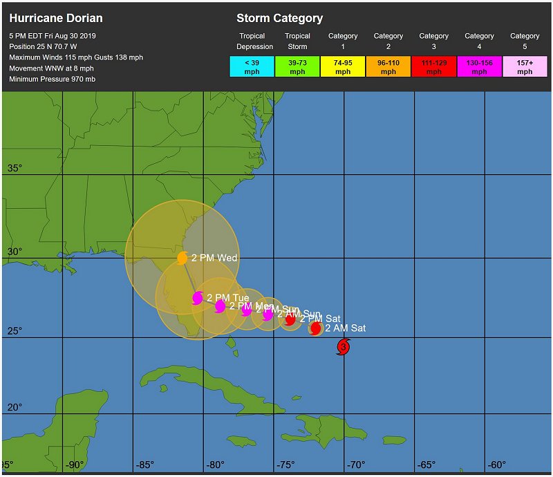
I think if you are anywhere on the Atlantic coast from Miami, FL to Cape Hatteras, you need to be on your toes. Some models are showing it hugging the Atlantic coast as it heads northward.
__________________
|
|
|
|
|
08-30-2019, 06:52 PM
|
#30
|
|
Z51
Join Date: Oct 2006
Location: Port Richey FL
Posts: 2,107
Name :
|
I don't think it ever get to FL.
|
|
|
|
|
Currently Active Users Viewing This Thread: 1 (0 members and 1 guests)
|
|
|
 Posting Rules
|
You may not post new threads
You may not post replies
You may not post attachments
You may not edit your posts
HTML code is Off
|
|
|
All times are GMT -4. The time now is 06:15 PM.
|


 Linear Mode

