-
Got the Contributing Memberships stuff finally worked out and made up a thread as a sort of "How-To" to help people figure out how to participate. So if you need help figuring it out, here's the thread you need to take a look at -> http://www.corvetteflorida.com/forums/showthread.php?t=3581 Thank you, everyone! Rich Z.
You are using an out of date browser. It may not display this or other websites correctly.
You should upgrade or use an alternative browser.
You should upgrade or use an alternative browser.
Hurricane Irma
- Thread starter Rich Z
- Start date
Cor66Vette
New member
ChasZ51 - I didn't plan on leaving, either. A Cat 1 may not be so bad. Wishing you and everyone the best.
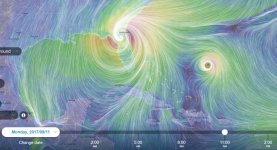
Well, I just checked Intellicast's website to check the latest and the hurricane tracking page give me this:
There are currently no active tropical storms reported.
Well I'm glad this is over with. Not as bad as I thought it would be....
:face_palm_02:
There are currently no active tropical storms reported.
Well I'm glad this is over with. Not as bad as I thought it would be....
:face_palm_02:
Cor66Vette
New member
Thanks for that, Rich- and for all the reports and updates.
:dancer01::dancer01::dancer01::dancer01::dancer01::dancer01::dancer01:
Cor66Vette
New member
Hey Rich. Scott is on the tube and he's telling a diferent tale about the storm. Is your Intellicast website correct? Ventusky shows Irma even stronger than before.
I'm not getting any forecast tracks from Intellicast any longer. I just get a page saying there are no active tropical storms. 
I wrote them an email and told them they need to fire whoever is in charge of their website. It is letting down people right when they need it the most. Bunch of dopes....
I wrote them an email and told them they need to fire whoever is in charge of their website. It is letting down people right when they need it the most. Bunch of dopes....
Cor66Vette
New member
Thanks for that. I thought I was going gaga! From what my local weather station says, Flagler is beyond the Hurricane scare zone, and Irma is expected to be downgraded to a Cat 1 by the time it gets here. Still, Cat 1 and Ventusky say wind gusts are around 85/90 mph.
So, is it better to go by Ventusky? I ask because the TV folks are showing Irma travelling north at a more westerly path.
So, is it better to go by Ventusky? I ask because the TV folks are showing Irma travelling north at a more westerly path.
If you look in the lower left hand corner of the Ventusky display, you can select from multiple tracking models. And there is come variance among them, so this is all just "best guess" stuff. It is best to recall that originally hurricanes had all female names because of their unpredictability. I think the best thing to do is to hope for the best but plan for the worst you can reasonably expect. I'm expecting maybe Cat 1 low range winds here at worst case. But more likely it will be tropical force at most.
If Irma can't swing out into the Atlantic and away from everyone, I think it making landfall and coming over land up the peninsula of Florida might be a blessing in disguise. It will be hell for the south of Florida while it is full strength at land fall, but if it were to just buzz saw up the Atlantic or Gulf sides, keeping the eye over water constantly keeping the full Cat 4 strength up, it would likely be far worse for a lot more people.
It is times like this, however, that I sometimes worry about living in the middle of the woods with all these darn trees all around me. They are just fine, and pretty and all, till they come toppling down on top of something.
CHASZ51
Z51
I have a feeling it could come up the gulf all the way up the state just offshore.If you look in the lower left hand corner of the Ventusky display, you can select from multiple tracking models. And there is come variance among them, so this is all just "best guess" stuff. It is best to recall that originally hurricanes had all female names because of their unpredictability. I think the best thing to do is to hope for the best but plan for the worst you can reasonably expect. I'm expecting maybe Cat 1 low range winds here at worst case. But more likely it will be tropical force at most.
If Irma can't swing out into the Atlantic and away from everyone, I think it making landfall and coming over land up the peninsula of Florida might be a blessing in disguise. It will be hell for the south of Florida while it is full strength at land fall, but if it were to just buzz saw up the Atlantic or Gulf sides, keeping the eye over water constantly keeping the full Cat 4 strength up, it would likely be far worse for a lot more people.
It is times like this, however, that I sometimes worry about living in the middle of the woods with all these darn trees all around me. They are just fine, and pretty and all, till they come toppling down on top of something.
I am sure i will lose power and won't be able to post for days or weeks.
Cor66Vette
New member
All or most of the TV reports show Irma, once it hits FL, travelling north in the middle to western portion of the state. With each subsequent report, Irma's path north bound gets slightly more westerly. Cat 5 while it's above water, then Cat 4? when it makes land. The Cat isn't labelled after it makes land and heads north, but is said to be Cat 1 when it arrives here in the Flagler/Jax area. TV also shows Hurricane warnings for ALL the counties south of Flagler. I hope that doesn't change except for the better, of course.
Too bad that weather site was f'd up. That was too good to be true, I suppose.
Too bad that weather site was f'd up. That was too good to be true, I suppose.
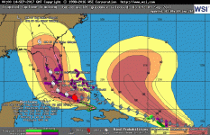
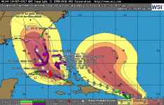
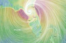
Well, well. Intellicast came back alive with their forecast screens. Here is the latest one they are showing. Note the wide gap between the forecast position at 8pm Sunday and 8pm Monday. That means the storm is going to pick up speed BIG TIME moving north. I'm thinking that is going to mean a lot of shear, which should weaken the storm dramatically once it gets caught up in that.
The track also appears to have the center of the storm staying over land once it makes landfall around Ft. Myers. So that, too, should weaken the storm rapidly. Still, with winds estimated to be 135 mph at landfall, not going to be any picnic in southwest Florida.
Some of the models on Ventusky are still showing the track being more center in the peninsula, however, so there is a bit of uncertainty about what the track will actually be. They are also showing landfall closer to Cape Sable too, which might be a good thing since that area is pretty much uninhabited.
Of course, all this is subject to change without notice.
Attachments
CHASZ51
Z51
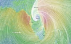
Well, well. Intellicast came back alive with their forecast screens. Here is the latest one they are showing. Note the wide gap between the forecast position at 8pm Sunday and 8pm Monday. That means the storm is going to pick up speed BIG TIME moving north. I'm thinking that is going to mean a lot of shear, which should weaken the storm dramatically once it gets caught up in that.
The track also appears to have the center of the storm staying over land once it makes landfall around Ft. Myers. So that, too, should weaken the storm rapidly. Still, with winds estimated to be 135 mph at landfall, not going to be any picnic in southwest Florida.
Some of the models on Ventusky are still showing the track being more center in the peninsula, however, so there is a bit of uncertainty about what the track will actually be. They are also showing landfall closer to Cape Sable too, which might be a good thing since that area is pretty much uninhabited.
Of course, all this is subject to change without notice.
If it don't turn soon you better get out of dodge.
CHASZ51
Z51
Looks like the house in Marathon that I was negotiating on will be gone .Must be a message sent from God .The good news is that there are three people in Florida I don't care for and they are on the west coast .
I would pick another place to live. After TX and now us, Insurance will get to the point they won't cover these homes on the water anymore.
Cor66Vette
New member
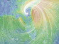
Quite a difference
The really weird thing about the Ventusky display is when you position the cursor to see the predicted wind speed, a LOT can change depending on the altitude selected. For instance, I positioned the cursor right at Tallahassee and got the following results for predicted windspeed:
The wind speed over water is a LOT higher than it is over ground, at least at the 10 m altitude. So I guess the important thing here, is to keep your head down. Fortunately we have a lot of trees around us, so likely the wind will mostly sklp over the tops of the trees. Unfortunately, some of the taller ones might decide to tip over.
- 10 m above ground = 25 mph
- 500 m above ground = 74 mph
- 750 m above ground = 85 mph
- 1000 m above ground = 89 mph
- 1500 m above ground = 99 mph
The wind speed over water is a LOT higher than it is over ground, at least at the 10 m altitude. So I guess the important thing here, is to keep your head down. Fortunately we have a lot of trees around us, so likely the wind will mostly sklp over the tops of the trees. Unfortunately, some of the taller ones might decide to tip over.
If it don't turn soon you better get out of dodge.
Yeah, I'm watching it closely. However, not sure what we could do if things got a lot worse. A LOT of gas stations are out of gasoline, and I would imagine we couldn't get to a place to stay that wasn't booked up solid on a single tank of gasoline. I went to the post office earlier today, and traffic, even here, was very heavy. The Shell station near the post office was closed down saying it was out of gasoline. The Murphy's Gas next to the Walmart had gasoline, but there were lines there of cars waiting to fill up. So I imagine that won't last long neither. Haven't checked the GasBuddy app yet this morning, so not sure what it is like elsewhere.
I actually got a phone message from the sheriff's department that they were recommending evacuations for anyone living along the coast in Wakulla county below route 98. We are roughly 10 miles north of route 98.
I'm just going to have to hope that the center of the storm stays over land and weakens substantially before it gets this far north. I expect we might lose power, though. And hope that if we get trees tipped over, they don't fall on anything important.