-
Got the Contributing Memberships stuff finally worked out and made up a thread as a sort of "How-To" to help people figure out how to participate. So if you need help figuring it out, here's the thread you need to take a look at -> http://www.corvetteflorida.com/forums/showthread.php?t=3581 Thank you, everyone! Rich Z.
You are using an out of date browser. It may not display this or other websites correctly.
You should upgrade or use an alternative browser.
You should upgrade or use an alternative browser.
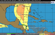
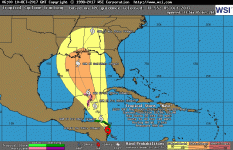
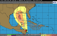
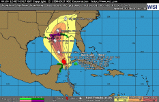
Tropics here we go again... Hurricane Nate
- Thread starter CHASZ51
- Start date
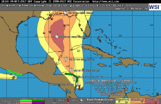
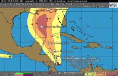
The forecast tracks I see on VentuSky are showing it moving further to the west between Texas and Louisiana.
Unfortunately, when a hurricane moves into the Gulf of Mexico, it makes landfall somewhere either in the USA or Mexico. I don't think I have ever seen one just dissipate over water, or turn around and head south and then out into the Atlantic.
Hopefully for everyone impacted the most it will strengthen to will be a category 1 storm.
Looks like you will get rain no matter what.
Well maybe. The local forecast is only calling for a 60 percent chance of rain through the weekend, and mentioning that tropical storm conditions are possible.
One of the guys on one of my other forums is kind of still got a raw nerve over the forecasts for Irma. He is over in Port Charlotte and followed the suggestions to evacuate. Went over to Ft. Lauderdale, and you know how that turned out. I'm hoping that another big storm doesn't kick up, because a lot of people here in Florida will likely choose to just ignore what will appear to be the "same ole' hype" about an approaching storm. Heck, I'm thinking that the moving target projections for Irma probably earned a lot of companies a lot of money from Florida residents either stocking up on supplies, or else evacuating and spending money on motels, restaurants and gasoline. I'm sure they won't mind more of that. Not to mention all the internet weather services that had tons more traffic and likely more money coming in from advertisers. Damn shame to think people would take advantage of something like this, but people ARE people. Seems many of them are just rats walking on two legs.
That will flip flop.
Very little doubt THAT will happen.
One good thing, though, is that once it gets up around here in north Florida (or where ever it really winds up making landfall), it looks like it's going to move quickly through the area.
CHASZ51
Z51
Kind of strange here in north Florida. Had a very wet Spring and Summer, then BOOM, the rain just stopped. We're running irrigation on the citrus so the fruits will not shrivel up on us.
Could be last you see till next June.
Could be last you see till next June.
Yeah, could be, but as long as I've been living here, we don't normally have dry winters in this area. It is the Spring months that tend to be dry around these parts. May is normally the driest month.
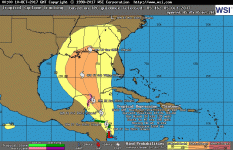
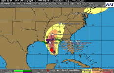
Anyway, looks like Nate is strengthening now and forecast to make landfall in Mississippi tonight with winds around 105mph.
Attachments
CHASZ51
Z51
Yeah, could be, but as long as I've been living here, we don't normally have dry winters in this area. It is the Spring months that tend to be dry around these parts. May is normally the driest month.
Anyway, looks like Nate is strengthening now and forecast to make landfall in Mississippi tonight with winds around 105mph.
Just think if it stalled and got to be a 4 or a 5. Our winters are not even cool anymore and almost no rain. It has just changed so much for us the last 7 years. But your winters are much colder anyways than ours 200 miles to the south.