• Got the Contributing Memberships stuff finally worked out and made up a thread as a sort of "How-To" to help people figure out how to participate. So if you need help figuring it out, here's the thread you need to take a look at -> http://www.corvetteflorida.com/forums/showthread.php?t=3581 Thank you, everyone! Rich Z.

Atlantic tropical storm development - Late August, 2019

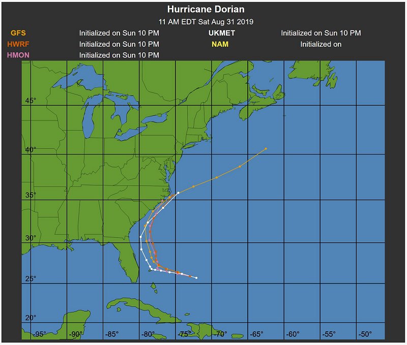
Yeah, you are probably correct. The forecast track on Ventusky now shows Dorian slowing down quite a bit when it gets close to the Florida coast, and gradually creeping northward just off the coast till it makes landfall in South Carolina. So quite likely that track will keep on moving more easterly and northerly until it misses landfall completely.

I guess these forecasts that cover a broad area of impact in the USA are good for business for the weather products industry for advertising revenue. :shrug01:
 
But heck, now the forecasts are predicting Dorian becoming a Cat 3 hurricane and making landfall around Daytona Beach sometime Sunday night thru Monday morning.
 
But heck, now the forecasts are predicting Dorian becoming a Cat 3 hurricane and making landfall around Daytona Beach sometime Sunday night thru Monday morning.

They keep pushing it south. It is a very small core system with the strongest winds only 15 miles from the center.
 
Yeah, but it is still likely to spawn tornadoes from the landfalling bands at a distance from the center. Those are completely unpredictable as to where they will drop out of the sky and really tear things up.
 
By Fri we will know much more. At least it is coming from across the state and not on my coast. But it could get out in the gulf and come toward you.
 
My first Florida hurricane since I was six and I may have to drive to Jacksonville to see it .I think Ft Myers is relatively safe but I went to walmart and bought the last rack of water .Filled up the wifes car but I don't know where we could go .I'm two blocks from the hospital so I can always go to the cafeteria .Maybe even find an empty room to take a shower .I'm old enough to pretend I'm senile if I get caught .

This is a good one to learn on .I'm sure there will be larger ones coming soon .
 
By Fri we will know much more. At least it is coming from across the state and not on my coast. But it could get out in the gulf and come toward you.

Yeah, could happen. Florida isn't all that wide and the elevation isn't all that high to knock all the punch out of a hurricane passing over it. And certainly the water temp in the Gulf is enough for it to regain power, especially if it just lingers around over water for any appreciable length of time. So it will depend on it's track. The sooner it gets over land, the better.

Had the battery go out on the Jeep last week, so I'm glad that didn't happen if we had to bail out and then discover that little problem. Bailing out will depend on what it looks like at the time. Cat 1, no sense in going anywhere. Cat 2, toss a coin. Cat 3 and above, we are out of here.
 
Strength at landfall has been raised to a category 4 hurricane. :(
 

Attachments

  • hurricane_dorian_08292019_1100am.JPG
    hurricane_dorian_08292019_1100am.JPG
    84.3 KB · Views: 417
Looks like the latest forecast model track is swinging the path to an abrupt northerly jog soon after making landfall somewhere between Miami and Titusville sometime Tuesday morning (09-03-2019).

hurricane_dorian_08302019_0500pm.jpg


I think if you are anywhere on the Atlantic coast from Miami, FL to Cape Hatteras, you need to be on your toes. Some models are showing it hugging the Atlantic coast as it heads northward.
 
Yeah, I have seen it slowing down concerning the forward motion. Would be real nice if it just parked itself out in the Atlantic and then swung north away from all land.
 
LOL!! I think you are hitting this one right on the nose.

hurricane_dorian_08302019_1100pm.jpg


They seem to be really hyping this one up before the "WHEW!! That was a close one!! Ain't that global warming a bitch?".
 
I'm up at 3:30 and the only news on was CNN and they we're saying possible cat 5 and most of eastern Florida could be destroyed .
At 4am our local station which has been dead nuts from day one gave their forecast .We're completely out of harms way in southwest Florida .We may get an inch of rain and light winds .The eye of the storm may not even hit land at least Florida .
 
CNN = Fake News Network, IMHO. If they said it was daylight out, I would have to go to a window to check on it. Did they happen to accuse Trump of being at blame for any damages? :rofl1:

Anyway, yeah, the "official" forecast track is pushing the storm further east with landfall *maybe* in South Carolina or North Carolina.

hurricane_dorian_08312019_0800am.jpg


There is a 11:00am update that shows virtually the same path.
 
Dorian is now a Category 5 hurricane. Sure hope it makes that turn to the north and then hopefully head northeast out to sea.

hurricane_dorian_model_09012019_1100am.jpg
 
Back
Top